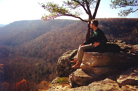
Duncan and I take a few minutes to enjoy the view from Raven Point
Dog Hole/Fiery Gizzard Loop,
South Cumberland Recreation Area, Tennessee
November 30, 2000
I loaded Duncan (my 2 year old Labrador) into the back of the Montero Sport and we pulled out of the garage at 3:05 am. Y’know, when you hit the interstate at 3:15 on a Thursday morning, you own it! The lack of traffic provided me with the opportunity to enjoy the beautiful night sky. There was no moon and the stars shown brightly, with Jupiter and Cassiopeia off my left shoulder as I headed north on I-59. I went through the drive-thru at Hardee’s in Trenton, Georgia at 5:15 and continued on. I soon realized it’s hard to drive and eat in the dark, so I stopped at a rest area just inside Tennessee to finish my biscuit and give Duncan a break.
I had called the South Cumberland State Park Visitor’s Center the day before and spoke with a lady about opening and closing times. She said they opened the gates around 6:30, and closed them at dark – there was no hiking on the trails after dark. This concerned me a little… what if I didn’t get back to my car before dark? Would I be locked in? These concerns prompted my early start time.
I arrived at the Fiery Gizzard trail parking area at 6:26 and sure enough, the gates were still locked. Fortunately, there was parking outside of the gates. That was a relief to me, the pressure was off, I wouldn’t be locked in. I put on my boots and Polartec 100 shirt, strapped on my pack, and Duncan and I hit the trail at 6:41. The sun was not quite up yet and it was a cool, crisp 36°.
My plan was to take the Dog Hole trail to Raven Point, then the Fiery Gizzard back to the parking area. The brochure entitled "Popular Day Hikes" refers to this as the "Dog Hole Gorge Loop", with a rating of "difficult" and length of 10 miles if you include Raven Point. From a photographer’s standpoint, I reasoned that the morning sun would be illuminating the west side of the canyon which would be my view as I hiked along the east side. Then, in the afternoon, the light would be better down in the canyon where I would photograph some of the waterfalls as I returned along the trail.
Having read that the Gizzard was a tough trail, I wanted to make good time on this first leg of the trip along the Dog Hole trail. So, after making the short climb up to the ridge, I adopted a brisk pace along the mostly level and easy trail. I stopped a couple of times briefly to check the view, once being at Werner Point. I hoped to reach Raven Point at least by 10:00. While hiking along I noticed some movement off in the woods...I stopped. It was a turkey. No, two…three…four! I watched as they trotted off below the ridgeline – a pretty sight in the open autumn woods. Duncan either didn’t see them or didn’t care.
I checked my map frequently trying to assess my position. I was tooling right along and all of a sudden, there was the sign for the Raven Point camping area. I looked at my watch and it was only 8:58. I was well ahead of my self-imposed schedule and felt surely this would give me plenty of time even if the trail in the canyon was really rough. I checked out the camping area for a possible backpacking trip here in the future, then trekked the half mile on out to Raven Point. We took about a 45-minute break here and enjoyed the view along with some snacks and took a few photos.
Duncan and I take a few minutes to enjoy the view from
Raven Point
I wanted to see the waterfall that was shown on the map near the campsite so we backtracked past the camping area and down to the top of Anderson Falls. I would have liked to go to the bottom of it for a photograph, but there was not an obvious trail down and I didn’t have the extra time to poke around looking for one. So, we headed back to the trail intersection, then turned down into the canyon on the Fiery Gizzard trail.
The map describes this section of trail as "arduous" if you’re climbing out of the canyon. As I continued down, down and down some more, over some pretty steep and rugged sections, I would have to agree with the description. I’ll admit to being glad to finally reach the canyon floor and level out a bit. The going was definitely slower as I began to make my way over the jumble of boulders that constitute the trail. It wasn’t necessarily "harder", just slower. You are almost more boulder hopping than walking and so can’t really fall into your normal rhythm, having to choose each step. Many of the boulders are loose and move when you step on them. Because of this, after a while I began to notice my ankles and lower legs feeling more fatigued than usual, having to use my stabilizing muscles more. But occasionally there are brief stretches of flat dirt that offer a welcome reprieve along the way. And it’s nice to stop for a moment to catch your breath and enjoy the scenery alongside the creek.
At one point I noticed a small fall in the creek and as I stopped to admire it, wondered if it was mentioned on the map. I read through the trail description and it read "Small falls below to right and cave above trail to left with a spring inside". Cave? Hmmm… I climbed the short distance up to the bluff line and sure enough, there was the cave. I could hear water trickling along inside, so I got my flashlight and camera out of my pack and ventured in. I didn’t go very far until setting up for a photograph of the stream and then heading back out. I don’t know how far back it may have been open, and couldn’t tell much with my small light, but being by myself I would not have gone further anyway.
It was about lunchtime now and a little ways after passing through the pile of huge boulders known as "The Fruit Bowl", I picked out a sunny rock and sat down and ate. Duncan took the opportunity to grab a quick nap.
Rested and re-energized, we strode on along the trail. With it being still so early in the afternoon, I was able to take the time to photograph the waterfalls I had passed on the way in. First Sycamore Falls, then the cascade in "Black Canyon", and finally Blue Hole Falls.
We got back to the trailhead at 2:23. Mine still was the only car in the parking lot. It appears as though Duncan and I had the entire area to ourselves the whole day. On the way out I stopped by the South Cumberland Visitor’s Center and viewed the displays there about the history of the area. I found it interesting.
I made a quick stop in Fort Payne for gas and food, then back on the road. I arrived home at 6:15, having traveled 400 miles this day – 390 by car and 10 by foot… a good day.
Want to see the photos from this trip? Back to Trip Reports
Since 12-12-00